The area around the Squarehouse
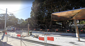 |
| View of the Squarehouse across ANZAC Parade |
 |
| Aerial View of the structures surrounding the squarehouse |
Since my plan is to connect NIDA and the squarehouse, the bridge will need to cross ANZAC Parade. However, there are multiple large trees blocking such connections, which prevent the bridge from staying close to ground.
The bridge can connect to the empty space on the roof above the foyer of NIDA centre, while the bridge can connect to the third floor or the roof of the squarehouse to minimalise impact to vegetations.
 |
| plan of the first floor of Squarehouse |
 |
| plan of the secondfloor of Squarehouse |
 |
| plan of the third floor of Squarehouse |
The blue circle in the plans of squarehouse indicate a suggestion to expand the staircase of the Squarehouse to accomodate for an influx of pedestrian movement of the bridge.
Seasonal Solar position
 |
| The angle of projection of the sun during winter |
 |
| The angle of projection of the sun during summer |


No comments:
Post a Comment